Location Model
Diagrams
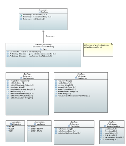
Place
Classes
Place
Parent class: RootEntity
Applied stereotypes:
Reference
reference: From TMF SID
Preliminary
OpenModelClass
support: MANDATORY
Attribute Name |
Type |
Mult. |
Stereotypes |
Description |
Defined in |
validFor |
TimePeriod |
0..1 |
OpenModelAttribute
Experimental |
Common::Location::ObjectClasses::Place::validFor |
|
geoCoordinates |
GeoCoordinates |
0..1 |
Reference
Preliminary OpenModelAttribute
|
Geographical coordinates |
Common::Location::ObjectClasses::Place::geoCoordinates |
civicAddress |
CivicAddress |
0..1 |
Reference
Preliminary OpenModelAttribute
|
Civic address |
Common::Location::ObjectClasses::Place::civicAddress |
name |
String |
0..1 |
Preliminary OpenModelAttribute
|
Represents a user-friendly identifier of an object. It is a (possibly ambiguous) name by which the object is commonly known in some limited scope (such as an organization) and conforms to the naming conventions of the country or culture with which it is associated. It is NOT used as a naming attribute (i.e., to uniquely identify an instance of the object). |
Common::Root::RootObjectClasses::RootEntity::name |
description |
String |
0..1 |
Preliminary OpenModelAttribute
|
Defines a textual free-form description of the object. |
Common::Root::RootObjectClasses::RootEntity::description |
id |
Identifier |
1 |
Preliminary OpenModelAttribute
|
Identifier of this information element. This attribute shall be globally unique. Unambiguously distinguishes different object instances. It is the naming attribute of the object. |
Common::Root::RootObjectClasses::RootEntity::id |
RootEntity
This is the top of the ONAP class hierarchy. The purpose of the RootEntity is to define a set of attributes that are common to all entities that derive from it. These properties enable us to name, describe, and identify all objects in the environment.
Applied stereotypes:
Preliminary
OpenModelClass
support: MANDATORY
Attribute Name |
Type |
Mult. |
Stereotypes |
Description |
Defined in |
name |
String |
0..1 |
Preliminary OpenModelAttribute
|
Represents a user-friendly identifier of an object. It is a (possibly ambiguous) name by which the object is commonly known in some limited scope (such as an organization) and conforms to the naming conventions of the country or culture with which it is associated. It is NOT used as a naming attribute (i.e., to uniquely identify an instance of the object). |
Common::Root::RootObjectClasses::RootEntity::name |
description |
String |
0..1 |
Preliminary OpenModelAttribute
|
Defines a textual free-form description of the object. |
Common::Root::RootObjectClasses::RootEntity::description |
id |
Identifier |
1 |
Preliminary OpenModelAttribute
|
Identifier of this information element. This attribute shall be globally unique. Unambiguously distinguishes different object instances. It is the naming attribute of the object. |
Common::Root::RootObjectClasses::RootEntity::id |
Data Types
CityQualifiers
Applied stereotypes:
Preliminary
Attribute Name |
Type |
Mult. |
Access |
Stereotypes |
Description |
cityName |
String |
1 |
RW |
Reference Preliminary OpenModelAttribute
|
Name of City, Township, or Parish |
cityDivision |
String |
0..1 |
RW |
Reference Preliminary OpenModelAttribute
|
Name of city division, ex. Borough, District, Ward, Chou |
cityNeighborhood |
String |
0..1 |
RW |
Reference Preliminary OpenModelAttribute
|
Name of neighborhood, ex. Block, Street group |
CivicAddress
Applied stereotypes:
Preliminary
Attribute Name |
Type |
Mult. |
Access |
Stereotypes |
Description |
country |
String |
1 |
RW |
Reference Preliminary OpenModelAttribute
|
The name of the country |
state |
String |
0..1 |
RW |
Reference Preliminary OpenModelAttribute
|
The name of the state or province |
region |
String |
0..1 |
RW |
Reference Preliminary OpenModelAttribute
|
The name of the region |
postalCode |
String |
0..1 |
RW |
Reference Preliminary OpenModelAttribute
|
The postal code or zip code |
city |
CityQualifiers |
0..1 |
RW |
Preliminary OpenModelAttribute
|
The name of the metropolitan area, city, township, borough, district, or ward. Allows further specific city sub-divisions to be specified, such as: division, borough, district, ward, chou, neighborhood, block, street group |
streetAddress |
String |
0..1 |
RW |
Reference Preliminary OpenModelAttribute
|
The street address |
lata |
String |
0..1 |
RW |
Preliminary OpenModelAttribute
|
Local access and transport area (LATA) represents a geographical area of the United States, used in U.S. telecommunications regulation. |
structureQualifiers |
StructureQualifiers |
0..1 |
RW |
Preliminary OpenModelAttribute
|
Additional pre-defined qualifier fields for a structure including: unit, floor, room, desk |
GeoCoordinates
Applied stereotypes:
Preliminary
Attribute Name |
Type |
Mult. |
Access |
Stereotypes |
Description |
mapDatum |
MapDatum |
1 |
RW |
Reference Preliminary OpenModelAttribute
|
Map Datum used for the coordinates given in this option. |
latitude |
String |
1 |
RW |
Reference Preliminary OpenModelAttribute
|
Latitude in binary geodetic form. A 34-bit fixed-point value consisting of 9 bits of integer and 25 bits of fraction. |
latitudeUncertainty |
String |
0..1 |
RW |
Reference Preliminary OpenModelAttribute
|
When mapDatum = WGS84, this field represents latitude uncertainty. Uncertainty = 2 ^ ( 21 - x ) x = 21 - ceil( log2( uncertainty ) ) |
longitude |
String |
1 |
RW |
Reference Preliminary OpenModelAttribute
|
Longitude in binary geodetic form. A 34-bit fixed-point value consisting of 9 bits of integer and 25 bits of fraction. |
longitudeUncertainty |
String |
0..1 |
RW |
Reference Preliminary OpenModelAttribute
|
When mapDatum = WGS84, this field represents longitude uncertainty. Uncertainty = 2 ^ ( 21 - x ) x = 21 - ceil( log2( uncertainty ) ) |
altitude |
String |
0..1 |
RW |
Reference Preliminary OpenModelAttribute
|
A 30-bit value defined by the Altitude Type field. |
altitudeUncertainty |
String |
0..1 |
RW |
Reference Preliminary OpenModelAttribute
|
When mapDatum = WGS84, this field represents altitude uncertainty. |
altitudeUnit |
AltitudeUnit |
0..1 |
RW |
Reference Preliminary OpenModelAttribute
|
Defines the unit for the altitude value. |
altitudeResolution |
String |
0..1 |
RW |
Reference Preliminary OpenModelAttribute
|
Encodes the number of high-order altitude bits that should be considered valid. |
Identifier
Applied stereotypes:
Preliminary
StructureQualifiers
Applied stereotypes:
Preliminary
Attribute Name |
Type |
Mult. |
Access |
Stereotypes |
Description |
unit |
String |
0..1 |
RW |
Reference Preliminary OpenModelAttribute
|
Unit (apartment, suite) |
floor |
String |
0..1 |
RW |
Reference Preliminary OpenModelAttribute
|
Floor |
room |
String |
0..1 |
RW |
Reference Preliminary OpenModelAttribute
|
Room |
desk |
String |
0..1 |
RW |
Reference Preliminary OpenModelAttribute
|
Seat, desk, cubicle, workstation |
placementInfo |
String |
0..1 |
RW |
Reference Preliminary OpenModelAttribute
|
Additional placement information, ex. shelf, rack |
poBox |
String |
0..1 |
RW |
Reference Preliminary OpenModelAttribute
|
Post office box number |
TimePeriod
A base / value business entity used to represent a period of time, between two timepoints
Applied stereotypes:
Preliminary
Attribute Name |
Type |
Mult. |
Access |
Stereotypes |
Description |
startDateTime |
DateTime |
1 |
RW |
OpenModelAttribute
|
An instant of time, starting at the TimePeriod Notes: If null, then represents to the beginning of time |
endDateTime |
DateTime |
1 |
RW |
OpenModelAttribute
|
An instant of time, ending at the TimePeriod: Notes: If null, then represents to the end of time |
Enumerations
AltitudeUnit
Contains Enumeration Literals:
METER:
FLOOR:
FOOT:
MapDatum
Contains Enumeration Literals:
WGS84:
NAD83 + NAVD88:
NAD83 + MLLW: